North Devon UNESCO Biosphere Reserve UK
  • Home
  • Map
  • Who We Are
    • Biosphere Team
    • Contracts
    • UNESCO MAB
    • Partners
    • Biosphere Strategy
    • Biosphere Foundation
  • What We Do
    • Projects
    • 25 YEP Pioneers >
      • Landscape Pioneer
      • Marine Pioneer >
        • MP Library
    • BCHT Project
    • Catchment Management >
      • CaBA Project
      • Catchment Sensitive Farming
      • Estuary Management >
        • Coastal Natural Flood Management
        • Estuary Project
      • Taw River Improvement Project
    • Community & Culture >
      • Biosphere road verges
      • Living Sustainably >
        • Green Pioneers
        • Walking for Health
    • Energy >
      • SE Context >
        • Biosphere Energy Plan
    • Forestry >
      • Woods 4 Water
    • Green Economy
    • Marine >
      • Marine Natural Capital Plan
      • Fishing Sustainably
      • Valuing Marine Ecosystem Services
    • Nature Improvement Area
    • Plastic Free North Devon Consortium
  • Our Biosphere
    • Our Twin Biosphere
    • Review Report
    • State of the Biosphere
    • Agriculture >
      • DEFRA Facilitation Funds
    • Cultural Heritage >
      • Arts Strategy
      • Giants in the Forest
      • Life's Journey
      • Crowdfunder Pledge for Nature
      • Pledge for Nature Project
    • Natural Environment
    • Picture Gallery
  • Out & About
    • The Tarka Trail >
      • Guidebook
    • Local Nature Reserves
    • Braunton Burrows
    • South West Coast Path
    • Marine Wildlife Code Of Conduct
  • Knowledge
  • News
  • Contact

Information for visitors

This helpful map, pdf leaflet and guidebook focusses on the shared-use-section between Braunton and Meeth. It is part of a European Cycle West project to jointly promote cycling routes in Britain and the South West. It is part of the "Velodyssey" route linking south-east Brittany, including the Iroise Biosphere Reserve and Devon.
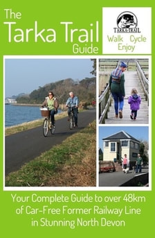
Guidebook for the Tarka Trail
A 48-page guide to the shared-use section of the Tarka Trail is now available to buy at www.tarkatrailguide.co.uk
The user-friendly guide details much of the various wildlife you might see as you travel.  It is also  packed with helpful information on facilities which are on or near the Trail such as car & cycle parking, trail surface, toilets, cafes and restaurants, camping and accommodation, bridleways, disabled accessibility and more. 
Get your copy here.
Picture

Tarka Trail Projects

  • Life's Journey Project
  • Audio Guide (shared use section) - Along the Tarka Trail shared use section there are 21 discovery posts with information on the history and wildlife of the Trail and the places it passes through. Download and/or listen to the audio guide as mp3 files.
  • Usage statistics
  • Management Plan

Guidance for users

DCC Leaflet for Tarka Trail
File Size: 1798 kb
File Type: pdf
Download File

Tarka Trail Code of Conduct
File Size: 73 kb
File Type: pdf
Download File

Guidance for horse riders
File Size: 67 kb
File Type: pdf
Download File

Tarka Trail vegetation management
File Size: 16 kb
File Type: pdf
Download File

 :
Picture
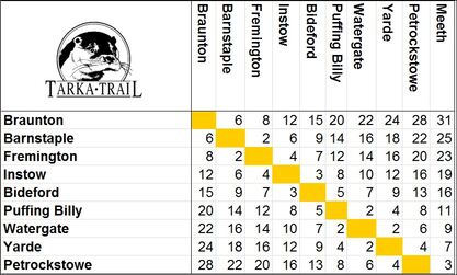
Distances (miles) - Click to enlarge

Google Street View

Picture
The shared-use section  (from Braunton to Meeth) is now live on Google Street View.

Take a look at these links below which use Google Streetview
Start of the shared-use section at Braunton
Velator wetland
Chivenor
On route to Barnstaple
Take a seat and admire the view
This former railway line has a smooth level surface
At Barnstaple follow 'Tarka Otter print' signs
Fremington Quay
Yelland
Instow Tunnel
Instow
Bideford Station
Iron Bridge - accross the Torridge
Tunnel under the A388 (use your lights)
Over the Torridge again
Torrington Station
Servis Farm - from this point on to Meeth, horse riding is permitted
Watergate - Tarmac surface ends - the surface is now compacted stone
Yarde Orchard Cafe
Meeth - the end of the multi-use section

Did you know that the old London and South West Railway route now used as the Tarka Trail replaced the older Rolle Canal built less than 40 years earlier. We are working to improve access to the remains of the canal and to tell their story. 

There are many valuable habitats beside the cycle track including estuary mud flats and salt marsh, oak woodland, hazel coppice, Devon hedges, ponds, streams, ditches, meadows and Culm grasslands. All these habitats need management whether it is cutting coppice, clearing out ponds, laying hedges or mowing meadows.


North Devon Biosphere
LIVING AND WORKING IN HARMONY WITH NATURE

Site Map

Home
Who We Are
Partners
Reports & Partnership Meeting Minutes
Periodic Review
What We Do
Action Plan
You & Your Biosphere
Natural Environment
Out & About
Braunton Burrows
Easy Access Trails
Local Nature Reserves
South West Coast Path
Tarka Trail
Tarka Trail Audio Guide Downloads
Cultural Heritage
Industry & Economy
Agriculture
Freshwater & Marine Industries
Fishing Sustainably
Living Sustainably
Sustainable Energy
Sustainable Energy Action Plan
Adapting to Sea Level Rise
Walking for Health

BioBlitz
Biodiversity Offsets
Catchment Sensitive Farming
Confluence
Giants in the Forest
Green Pioneers
Investing in Nature
Life's Journey
Marine Conservation Zones
Nature Improvement Area
North Devon Cookbook
Sustainable Farming Award
Taw River Improvement Project
Valuing Marine Ecosystem Services
Visitor Gifting with Marsdens Cottage Holidays
Learning & Research
Our Twin Biosphere
Learning Resources
People and Environment
Research
News
Subscribe to Our Newsletter
​
Newsletter archive
Contact
​
Privacy Policy

Search this Site

​North Devon Biosphere, 1st Floor Taw View, North Walk, Barnstaple, North Devon, EX31 1EE, UK
telephone: 01271 388647