Shared use section between Braunton and Meeth
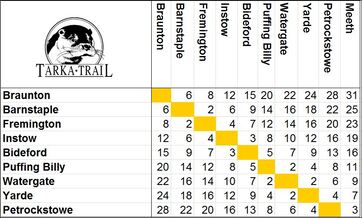
The 31 mile stretch between Meeth and Braunton runs along the line of an old railway, is part of the National Cycle Network (routes 27, Devon Coast to Coast and 3, West Country Way) and totally traffic free. Along this stretch, interpretation boards and other information help you discover the heritage, culture and natural features you can see. Horses are welcome on this part of the Trail between Torrington (Servis bridleway) and Meeth. More
A few miles south of Petrockstowe Halt, Devon Wildlife Trust have opened Meeth Quarry Nature Reserve to the public. This new and exciting reserve can be accessed directly from the Tarka Trail and some routes around the reserve are accessible to cyclists. As the site continues to develop we think it will become a ‘must see’ destination for those visiting the Tarka Trail. Visit Devon Wildlife Trust to find out more.
The shared use section of the Trail is part of a European Cycle West project to jointly promote cycling routes in Britain and the South West. It is part of the "Velodyssey" route linking south-east Brittany, including the Iroise Biosphere Reserve and Devon.
|
Tarka Trail Projects
Guidance for users
![]()
![]()
![]()
![]()
|
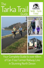
Guidebook for the Tarka Trail
A 48-page guide to the shared-use section of the Tarka Trail is now available to buy online, and at local bookshops, cycle hire shops and Tourist Information Centres. The user-friendly guide details much of the various wildlife you might see as you travel. It is also packed with helpful information on facilities which are on or near the Trail such as car & cycle parking, trail surface, toilets, cafes and restaurants, camping and accommodation, bridleways, disabled accessibility and more.
Get your copy here. |
Google Street View

The shared-use section (from Braunton to Meeth) is now live on Google Street View.
Take a look at these links below which use Google Streetview
Start of the shared-use section at Braunton
Velator wetland
Chivenor
On route to Barnstaple
Take a seat and admire the view
This former railway line has a smooth level surface
At Barnstaple follow 'Tarka Otter print' signs
Fremington Quay
Yelland
Instow Tunnel
Instow
Bideford Station
Iron Bridge - accross the Torridge
Tunnel under the A388 (use your lights)
Over the Torridge again
Torrington Station
Servis Farm - from this point on to Meeth, horse riding is permitted
Watergate - Tarmac surface ends - the surface is now compacted stone
Yarde Orchard Cafe
Meeth - the end of the multi-use section
Did you know that the old London and South West Railway route now used as the Tarka Trail replaced the older Rolle Canal built less than 40 years earlier. We are working to improve access to the remains of the canal and to tell their story.
There are many valuable habitats beside the cycle track including estuary mud flats and salt marsh, oak woodland, hazel coppice, Devon hedges, ponds, streams, ditches, meadows and Culm grasslands. All these habitats need management whether it is cutting coppice, clearing out ponds, laying hedges or mowing meadows.